Tahoe's Best
Lake Tahoe, Tahoe National Forest
120x60 REI Logo
Innovative quality for over 30 years
Home
Site Map
Text Search
Feedback
Hiking in Lake Tahoe

Hiking in Lake Tahoe

Trails by Region
Popular Short Hikes
Horseback Trails
Maps
Tips
Wilderness Info
Contact Info


Horseback Riding Trails

[Bayview Trail, Big Meadows to Kingsbury, Brockway Summit to Tahoe City, Carson Pass to Highway 50, Meeks Bay Trail, Spooner Summit to Kingsbury, Spooner Summit to Tunnel Creek, Horseback Camping Tips]

Riding in the backcountry is a wonderful experience. You and your horse will enjoy some of the most beautiful scenery available. The following outline suggests several trails located around Lake Tahoe.
Weather conditions can change rapidly. Be prepared with proper clothing and equipment, no matter how short the hike. If you plan to camp and use a camp stove or have a campfire, be sure to obtain a campfire permit available free from any Forest Service office.
Desolation Wilderness users need to obtain a Wilderness Permit for any ride into the Wilderness. (The Bayview and Meeks Bay trails are the wilderness). Day riders can obtain a permit at the self-service stations located at the trailheads. Overnight users must obtain a permit in person from the Forest Service office of Visitor Center. REMEMBER...open campfires are NOT allowed in Desolation Wilderness!
  • Bayview Trail
    • Difficulty: Strenuous
    • Elevation: 6,910'/8,440'
    • Mileage (one-way): 5 miles to Dicks Lake
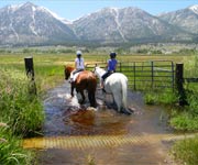
      • Take Highway 89 north from South Lake Tahoe approximately 8 miles to the Bayview Campground across from Inspiration Point. Corrals and watering facilities for horses are available at the trailhead. Camping is allowed for 48 hours.
      • Offering magnificent views of Emerald Bay and Lake Tahoe, this steep trail leads you up the side of Maggie's Peak into Desolation Wilderness. Stop at Granite Lake for a short rest along the way. In 2.7 miles this trail intersects with the Eagle Falls Trail leading you to Dicks Lake and the three Velmas.
  • Big Meadows to Kingsbury (RIM Trail)
    • Difficulty: Moderate
    • Elevation: 7,720'/9,800'
    • Mileage (one-way): 22.3 miles
      • From the junction of Highway 89/50 in Meyers, take Highway 89 five miles to the Big Meadows parking lot on the left. There are toilets and parking for trailers here.
      • Breathtaking views of Lake Tahoe, Hope Valley and the Carson Valley can be seen along this trail. There are three possible water stops along the way. The first is at Tucker Flat, a second near Armstrong Pass and a third at Star Lake.
  • Brockway Summit to Tahoe City (RIM Trail)
    • Difficulty: Moderate
    • Elevation: 6,240'/7,800'
    • Mileage (one-way): 18.5 miles
      • Take Highway 267 from Highway 28 on the north shore to a dirt pull-off, just north of a "Leaving National Forest Land" sign (½ mile south of the summit).
      • Panoramic views of the High Sierra, the Truckee River Canyon and Lake Tahoe can be seen from this trail. Watson Lake, a small picturesque lake perfect for a base camp, is located 6.5 miles from the trailhead. In the spring, just beyond the lake, beautiful meadows filled with wildflowers can be enjoyed.
  • Carson Pass to Highway 50 (PCT)
    • Difficulty: Strenuous
    • Elevation: 7,380'/8,990'
    • Mileage (one-way): 13.4 miles
      • From the junction of Highway 89/50 in Meyers, take Highway 89 up and over Luther Pass to Highway 88 and turn right. One mile past Carson Pass, turn at the sign that says "Woods Lake." Park in the dirt parking area. Camping is allowed but there are no toilets or water.
      • A portion of the Pacific Crest Trail (PCT) begins on the other side of the highway. Several options are possible from this trailhead. The trail to Showers Lake is 5 miles long, leading through meadows with views of the surrounding mountains. A second trail leads past Meiss Lake to Dardanelles Lake and then into the heart of Meiss country. A third option is the long trip up the PCT to Highway 50 near Echo Summit.
  • Meeks Bay Trail
    • Difficulty: Moderate
    • Elevation: 6,240'/8,880'
    • Mileage (one-way): 6.3 to Stony Ridge Lake
      • Take Highway 89 east from South Lake Tahoe. You will see a sign that says "Meeks Bay." After crossing a short bridge, look for a small cabin on the left and park in the dirt lot by the Desolation Wilderness sign.
      • This moderate ride takes you along the northernmost part of the  unofficial Tahoe-Yosemite Trail. After following a road for approximately 1.3 miles, the trail passes a small spring, parallels Meeks Creek and continues upward into a forested valley. A chain of alpine lakes can be seen before the trail ascends 1,000' up a series of switchbacks leading to Phipps Pass. A wilderness permit is required.
  • Spooner Summit to Kingsbury (RIM Trail)
    • Difficulty: Moderate
    • Elevation: 7,000'/8,800'
    • Mileage (one-way): 12 miles
      • Park at the Spooner Summit Rest Area located along Highway 50. Restrooms are available.
      • The trail begins behind the Nevada Department of Transportation building. Several views of the Carson Valley as well as glimpses of Lake Tahoe can be seen along this forested trail. Off-road vehicle (OHV) roads can be used for loops and access to Kingsbury Grade.
  • Spooner Summit to Tunnel Creek (RIM Trail)
    • Difficulty: Moderate
    • Elevation: 7,000'/8,600'
    • Mileage (one-way): 13 miles
      • Take Highway 50 approximately ½ mile north from the junction of Highway 50 and 28. Parking is located just beyond the summit to your left.
      • This trail provides wonderful views of the Carson Valley as well as glimpses of Lake Tahoe along a forested trail. Just before Snow Peak, the trail forks giving you two options. The right fork eventually leads you to Tunnel Creek Road which is gated, meaning you will need to come back the way you came. The left fork leads you down steep switchbacks to North Canyon Road. Towards the bottom of the switchbacks, there is a primitive campground with pit toilets and picnic tables but no water. From here you can turn right on the road which leads to Marlette Lake or left which leads back to Spooner lake (10 miles round trip). A connector trail leads around Spooner Lake and back up to the parking lot.

_________________________________________

Tahoe Rim Trail

Forest Service logo

The Tahoe Rim Trail is one of the world's premier trails and is marketed as a 165 mile loop trail. In reality, it is longer and for thru-hikers, you must include road sections. So, for planning purposes, the total mileage is closer to 164 miles.  

It is a trail that offers something for everyoneHiking, horseback riding and skiing are allowed on all portions of the trail.

Click here for more info ....

_________________________________________

Horseback Camping Tips

  1. Use a picket line and move it every day. This prevents your horse from digging a trough around a tree and injuring the root system. Hobbling is the most preferred method. Use a bell to find your animal. Train your horse at home to this new experience so you won't have a run away.
  2. Keep stock out of the camp area and spread manure piles to speed the breakdown.
  3. Tie stock at least 200 feet from any water source. Stock should be led to a rocky spot where little damage will occur. Soft or marshy lake edges should be avoided.

You will find information on  horseback riding stables and boarding facilities in Tahoe's Best 'Places to Go' guide.

Forest Service logoThe Horseback Riding Trail information contained within this page courtesy of the US Forest Service. If you have questions, contact the Forest Service at:
Lake Tahoe Basin Management Unit
870 Emerald Bay Road, Suite #1
South Lake Tahoe, CA 96150
(530) 573-2600
URL: http://www.tahoesbest.com/Hiking/horsebacktrails.htm


Trails by Region ] Popular Short Hikes ] [ Horseback Trails ] Maps ] Tips ] Wilderness Info ] Contact Info ]

Ride Tahoe's Best

[ Lake Tahoe Biking ] [ Lake Tahoe Boating ]
[ Lake Tahoe Calendar ] [ Lake Tahoe Camping ]
[ Lake Tahoe Catering ]  [ Lake Tahoe Fishing ]
[ Lake Tahoe Golf ]   [ Lake Tahoe Hiking ]
[ Lake Tahoe Hotels ] [ Lake Tahoe Places To Go ]
[ Lake Tahoe Real Estate ]   [ Lake Tahoe Restaurants ]
[ Lake Tahoe Skiing ] [ Lake Tahoe Transportation ]
[ Lake Tahoe Weather ] [ Lake Tahoe Weddings ]
  [ Lake Tahoe Home Page [ Lake Tahoe Vacation Rentals ]
[ Lake Tahoe Resources ]


Copyright © 2003 BlueSky Communications, LLC., Lake Tahoe, Ca.
To Advertise with TahoesBest.com, click here.
All Rights Reserved. Please review our Terms of Use.
Send mail to the webmaster with questions or comments about this web site.